This is the last installment of A. V. Comings report on their 1916 voyage down the Columbia River.
 DINNER on the night of our hard journey through the windswept water above Celilo, as related in the last chapter, was a real function. For, two days previously, a kindhearted rancher, who must have thought we looked “lean and hungry,” presented us with a fine mallard duck he had just killed. And this night Mr. M. Duck was served up to the two hungriest men on the Columbia river.

I made a reflector oven from a five-gallon Standard oil can, cutting it from top to bottom cornerwise, and the delicious, gamey duck, stuffed and spitted and roasted before an open fire in the improvised reflector, tasted better to us than any feast ever spread beneath the bright lights. We had the spice of real outdoor appetites, whetted on a keen
wind by strenuous exertion, and we ate—ate big, talked little, and were supremely happy.
 Our flickering fire east deep shadows where Miller had laid the inviting bed, and the full rising moon found us dead asleep under our sheltering “tarp.”
The wind blew itself out during the night, and morning dawned clear as crystal. I climbed the rocky shelves between our camp and the river soon after getting up, and as I topped the last one, I fairly gasped as Mt. Hood, glistening in the morning sun, burst upon my sight with startling unexpectedness. This was our first sight of the wonderful mountain, and its sharp ice cone, sparkling like a “blue” diamond, awed us into that silent admiration that is about the best tribute nature gets from man.
From then on, we had Mt. Hood with us until we were below Portland, and saw it from many angles and in many moods, all of which were beautiful.

Just around the corner below our camp, when we got under way, we ran into Hell’s Gate rapids and were soon being swept along mercilessly between high, broken volcanic rocks. We steered into a small eddy near one, and landed to take pictures of the “Gate,” just below us.

It looked like a blank wall, with no opening discernible to the eye. Perpendicular walls of dark brown volcanic rock, with the water swirling in giant eddies at their base, and no telling what was just around the corner. The whole Columbia compressed into a narrow, deep gorge, is Hell’s Gate, and, at high water, it lives up to its name.
We went through like a chip, however, with never a trouble from start to finish and headed straight across the river to the Oregon shore, where the new Celilo canal has its up-river terminal. The river is broad and calm from Hell’s Gate to the canal, though the roar of Tumwater Falls and the Celilo rapids is in one’s ears as a warning to proceed with care.

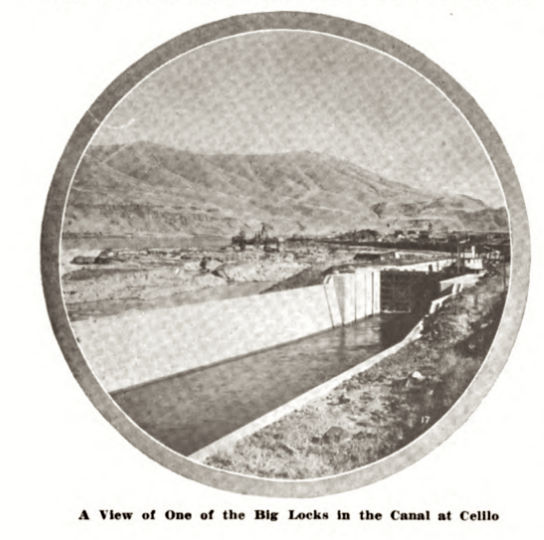
The Celilo canal, the real “reason” for our trip (as though two men who love the out-of-doors need have a “reason”), proved one of the most interesting spots on the river. The entrance is on the Oregon side, just above Tumwater Falls, which mark the up river limit of the famous Dalles of the Columbia.
The roaring Dalles is the name given by early French voyageurs, who used to shoot the rapids in their big, able bateau, and it means literally “flat stones.” For ten miles the river, compressed into narrow channels between the lava rock, boils on at a terrific rate, and though steamers have negotiated the river through this treacherous part of the stream, it has been only at high water, and even then a tremendously hazardous trip.

Tumwater Falls, with a drop of twenty feet at low water, such as we experienced, has been crossed by steamers when the river is at its highest stage, and the walls of the canal, twenty-five feet high in places, is not high enough to retain the river when it is at its flood stage.
The government has spent many millions in building this canal, with its series of splendid locks that drop a boat gradually from the upper river to the lower, a difference in levels of 60 feet at high water, and of 80 feet at low water. The entire canal and locks extend over a
distance of ten miles, through solid rock which had to be blasted out for this purpose.

While a portion of the canal is lined with concrete, much of it still presents its jagged walls to the passing boat and woe betide the steamer that is not protected on both sides by long logs, lashed in such a way that they act as fenders.
We locked through the canal with the steamer Twin Cities, the first craft through the canal in over two weeks, due to a shutdown caused by a break in one of the retaining walls.
(I have to add here that the steamer Twin Cities sunk on the night of March 25, 1916. )
Below the canal we entered the main river again, full of swirling Waters flowing on through a deep, narrow channel toward the city of The Dalles, on the Oregon side, a very attractive place, at which we spent the night.

For several days we had seen, far to the eastward as we floated down the stream, the hazy outlines of the magnificent Cascades, and the next morning we soon found ourselves in the first foothills. The perpendicular basaltic cliffs were succeeded gradually by the sloping sides of miniature mountains, and by 9:15, when we passed the mouth of the Klickitat, we were in the midst of the softer scenery that makes the Cascades the most beautiful of all the American mountain ranges.
The autumn foliage was still beautiful, for the temperature was such that the reds and browns and yellows of autumn leaves still held their brilliant hues. And each turn revealed new vistas of gradually higher mountains, clothed with magnificent forests of pine and larch
and maple. Grants Castle we passed, a wonderful pile of columnar basalt, and the remains also of Louis Hill’s projected highway along the Washington side of the river, that was abandoned through lack of public spirit on the part of that great state.
One after another we passed beautiful or historical spots, and at 10:30 landed on famous Memaloose Island, the “Island of the Dead,” which for centuries was used by the Indians along the Columbia as a burial place for their departed. Piles of human bones, Indian bones, it is true, yet the remains of beings having within them during life that same divine spark that is in you and me, were scattered everywhere, where they had been kicked and piled and probed by modern vandals seeking what they could find of ancient trinkets. Mayhap we looked into the vacant sockets where once flashed Kamiakin’s eyes, or pushed aside with our boots the mortal remains of hands that once signed friendship to Lewis and Clarke. One is
tempted to muse over the past on such a spot, but time forbade lengthy retrospect, and we were soon again on our way.

A few miles below we entered into a stretch of water that held us thoroughly entranced. Ahead, and far up on the mountain side, we could make out the white houses, the church steeples, and the winding streets of White Salmon, nestled among the trees as snugly as a
robin’s nest. “Lucky people, they,” thought I, for their view up and down the river is magnificent, and, straight across the Columbia, up the superb valley of Hood River, glistens the ice-coated crown of shimmering Mt. Hood; their’s to see in all its moods as long as time endures.

The Columbia was like a mirror on this gorgeous morning, and we floated on a veritable river of enchantment. It is hard to give you a consistent idea of the beauty of this trip through the Cascades, this journey through the only gap in this grand chain of mountains where a river flows from its western side through to the sea. The mountains constantly grow in size, till your little craft is but a dot in the vast gorge. In many ways it reminded
me much of the wonderful inlets on the British Columbia coast, where the Pacific penetrates inland between mountain walls a mile high and over.


We caught today our first glimpse of the Columbia Highway, that superb automobile roadway built at a cost of millions, and which is the peer of any similar boulevard in the world. We saw it winding around mountain side, or crossing deep gorges on artistic bridges, or edging the river close to the shores, and always it was placed just so the autoist could enjoy to the utmost the wonderful scenery about him.
We passed, too, today, the remains of the “sunken forest,” well preserved stumps of trees which were once above the level of the river, but which some convulsion placed below the surface except at lowest water.
At four we camped in a rocky nook on the Washington shore, just a short distance above the Cascade Locks. A thick fog covered everything the next morning, but it cleared soon and we were landed at Cascade Locks by 9 o’clock. These locks, in charge of Mr. Val Tompkins,
were opened to traffic in 1896, making possible the navigation of the river from the Pacific to The Dalles. Mr. Tompkins, to whom we had a letter of introduction, showed us every courtesy, and made our 24-hour stay at the locks extremely pleasant and profitable. In a recent letter, Mr. Tompkins says:
Rain, which prevented photography, kept us at the locks till the following day, hoping against hope that the weather might clear so that we could take the pictures we wanted. We had no such luck, however, so early on the morning of October 22d we locked through
and were on our way.
As one’s boat leaves the locks at this point, the full current of the Columbia, sweeping along at nine miles an hour, endeavors to set the boat upon a reef directly across the channel from the Oregon side, and only a little way down the stream. We fought our way across the stream, inch by inch, and cleared the reef with a fair margin, though what might have happened had our little Ferro stopped makes me shiver even yet. From there to Bonneville, a few miles down the river, is the last of the swift water, and we went whirling along so fast we hardly had time to watch the scenery we were passing. The beauties of the lower Columbia have so often been described and so often pictured, that I will not try to do them justice here.
Castle Rock, Rooster Rock, the wonderfully graceful Multnomah, Bridal Veil and Horse Tail falls, all were passed in this day’s run, and they are in themselves sufficiently beautiful to make it worth any man’s time to take the river trip from Portland to the Cascade Locks, even though he goes no farther.

Broadening out into a dignified, sweeping river a mile in width, the Columbia carried us on and on that day till 4 in the afternoon, when I landed Miller and all his dunnage at the ferry wharf in Vancouver, business making it necessary for him to be in Seattle the next day.
That night I made camp alone two miles below that historic city, and though it rained during the night I slept snugly beneath that “tarp” that good George Broom had made me take.
To Portland the next day was an easy and thoroughly interesting trip, for the weather was clear and beautiful and the busy Willamette river, with its shipping, and its mills, and its pretty villages along the shores, is teeming with interest always.
At the Von der Werth boat house my dunnage was stored and my boat cared for, and Saturday afternoon and Sunday I spent in Portland, where Pacific Motor Boat is known to all devotees of the water, and where any member of its staff is always given a hearty and sincere welcome.
“From the head of navigation to the sea” I had promised myself when I planned this trip, and I had no intention of ending it at Portland. So, Monday morning, I again donned my cruising togs, took aboard a little more gas, and was early churning the waters of the Willamette on the last lap of our long journey. Most of the day I had the distant company of three magnificent mountains, Mt. Hood, Mt. Adams and Mt. St. Helens, and I skimmed along the placid river in the full enjoyment of all that fell within my vision.

The shores of the Columbia below Portland are low and flat, and many beautiful ranches are on either hand. That night I slept ashore at Kalama, my outfit being generously stored by Jack Reed, one of the best known motor boat men on the river. Mr. Reed runs the Kalama-
Goble ferry, motor boats of course, and gave me much interesting early history of Columbia river motor boating.
The next day took me along a constantly widening river, and, when the wind began to make things interesting for me in the afternoon, I headed toward the Oregon shore and entered one of that labyrinth of canals that network that side of the river. All afternoon I wound around and around through these canals, seeing only an occasional fisherman or a curious cow, or dense growths of small trees that almost arched their tops across the stream. And later in the afternoon, when I almost despaired of ever getting out into the open river again, I suddenly burst upon Westport, where a huge lumber mill and loading ocean-going vessels gave me an abrupt jar, so different was it from what I had seen all afternoon.
That night I swung to a peaceful mooring a hundred feet from the Oregon shore, and, save for the fact that I nearly stood on my head when the bar tug Walulla, steaming under forced draft to the rescue of a foundering windjammer of the jetty, went charging by, I spent a very pleasant night.
Before daylight the next day, the last of my trip, I was under way and, skirting the Oregon shore to avoid the bars of the five-mile wide river, I came by easy running almost to Tongue Point, the last barrier between the old Pacific and me. A strong northeast wind had blown up during the morning, however, and I found it expedient to head into a little harbor on the east side of Tongue Point, exactly as Lewis and Clark had headed in for the same reason over a century before.
And there, while the waves beat outside, I ate one of the finest breakfasts I ever ate anywhere, and it was in the dining room of a fisherman’s cabin. J. P. Jensen was the fisherman; he knew Pacific Motor Boat as an old friend, as do most of the fishermen along the Columbia, and his hospitality was thoroughly enjoyed, you may be sure.

The wind went down with the turn of the tide, and shortly after 10 I rounded Tongue Point, and, like thousands that have gone before, fur traders, up-river Indians, explorers, adventurers, rode in my little craft to the first swells of the good old Pacific, lying away off in the haze of the western distance. A few minutes took me to the Tongue Point buoy station of the United States lighthouse department, where my little engine was shut off for the last time, and my journey was ended.
Three hundred and seventy-five miles through widely varying country, through calm and rapids, past sandy desert and populous cities, was this trip of ours, the first by motor boat from Priest Rapids to the sea.
Enjoy it?
Every second, night and day.
It’s a trip for any man who loves the great outdoors, and I can commend it particularly to that man who is seeking something out of the ordinary, who is tired of the old forms of amusement. He will get something quite different in this journey, and variety always.
The wonderful, weird, enchanting Columbia, that has borne on its bosom the vanguard of mighty empire, whose shores have been transformed from the hunting grounds of the painted savage to the home of a happy, prosperous people, and that today bears giant ocean liners where only yesterday were dugout canoes, will be there waiting for him
(THE END)


I made a reflector oven from a five-gallon Standard oil can, cutting it from top to bottom cornerwise, and the delicious, gamey duck, stuffed and spitted and roasted before an open fire in the improvised reflector, tasted better to us than any feast ever spread beneath the bright lights. We had the spice of real outdoor appetites, whetted on a keen
wind by strenuous exertion, and we ate—ate big, talked little, and were supremely happy.
 Our flickering fire east deep shadows where Miller had laid the inviting bed, and the full rising moon found us dead asleep under our sheltering “tarp.”
 The wind blew itself out during the night, and morning dawned clear as crystal. I climbed the rocky shelves between our camp and the river soon after getting up, and as I topped the last one, I fairly gasped as Mt. Hood, glistening in the morning sun, burst upon my sight with startling unexpectedness. This was our first sight of the wonderful mountain, and its sharp ice cone, sparkling like a “blue” diamond, awed us into that silent admiration that is about the best tribute nature gets from man.
From then on, we had Mt. Hood with us until we were below Portland, and saw it from many angles and in many moods, all of which were beautiful.

Just around the corner below our camp, when we got under way, we ran into Hell’s Gate rapids and were soon being swept along mercilessly between high, broken volcanic rocks. We steered into a small eddy near one, and landed to take pictures of the “Gate,” just below us.

It looked like a blank wall, with no opening discernible to the eye. Perpendicular walls of dark brown volcanic rock, with the water swirling in giant eddies at their base, and no telling what was just around the corner. The whole Columbia compressed into a narrow, deep gorge, is Hell’s Gate, and, at high water, it lives up to its name.
We went through like a chip, however, with never a trouble from start to finish and headed straight across the river to the Oregon shore, where the new Celilo canal has its up-river terminal. The river is broad and calm from Hell’s Gate to the canal, though the roar of Tumwater Falls and the Celilo rapids is in one’s ears as a warning to proceed with care.

The Celilo canal, the real “reason” for our trip (as though two men who love the out-of-doors need have a “reason”), proved one of the most interesting spots on the river. The entrance is on the Oregon side, just above Tumwater Falls, which mark the up river limit of the famous Dalles of the Columbia.
The roaring Dalles is the name given by early French voyageurs, who used to shoot the rapids in their big, able bateau, and it means literally “flat stones.” For ten miles the river, compressed into narrow channels between the lava rock, boils on at a terrific rate, and though steamers have negotiated the river through this treacherous part of the stream, it has been only at high water, and even then a tremendously hazardous trip.

 |
| Upper Tumworth |
Tumwater Falls, with a drop of twenty feet at low water, such as we experienced, has been crossed by steamers when the river is at its highest stage, and the walls of the canal, twenty-five feet high in places, is not high enough to retain the river when it is at its flood stage.
The government has spent many millions in building this canal, with its series of splendid locks that drop a boat gradually from the upper river to the lower, a difference in levels of 60 feet at high water, and of 80 feet at low water. The entire canal and locks extend over a
distance of ten miles, through solid rock which had to be blasted out for this purpose.

While a portion of the canal is lined with concrete, much of it still presents its jagged walls to the passing boat and woe betide the steamer that is not protected on both sides by long logs, lashed in such a way that they act as fenders.
We locked through the canal with the steamer Twin Cities, the first craft through the canal in over two weeks, due to a shutdown caused by a break in one of the retaining walls.
(I have to add here that the steamer Twin Cities sunk on the night of March 25, 1916. )
Below the canal we entered the main river again, full of swirling Waters flowing on through a deep, narrow channel toward the city of The Dalles, on the Oregon side, a very attractive place, at which we spent the night.

For several days we had seen, far to the eastward as we floated down the stream, the hazy outlines of the magnificent Cascades, and the next morning we soon found ourselves in the first foothills. The perpendicular basaltic cliffs were succeeded gradually by the sloping sides of miniature mountains, and by 9:15, when we passed the mouth of the Klickitat, we were in the midst of the softer scenery that makes the Cascades the most beautiful of all the American mountain ranges.
The autumn foliage was still beautiful, for the temperature was such that the reds and browns and yellows of autumn leaves still held their brilliant hues. And each turn revealed new vistas of gradually higher mountains, clothed with magnificent forests of pine and larch
and maple. Grants Castle we passed, a wonderful pile of columnar basalt, and the remains also of Louis Hill’s projected highway along the Washington side of the river, that was abandoned through lack of public spirit on the part of that great state.
One after another we passed beautiful or historical spots, and at 10:30 landed on famous Memaloose Island, the “Island of the Dead,” which for centuries was used by the Indians along the Columbia as a burial place for their departed. Piles of human bones, Indian bones, it is true, yet the remains of beings having within them during life that same divine spark that is in you and me, were scattered everywhere, where they had been kicked and piled and probed by modern vandals seeking what they could find of ancient trinkets. Mayhap we looked into the vacant sockets where once flashed Kamiakin’s eyes, or pushed aside with our boots the mortal remains of hands that once signed friendship to Lewis and Clarke. One is
tempted to muse over the past on such a spot, but time forbade lengthy retrospect, and we were soon again on our way.

robin’s nest. “Lucky people, they,” thought I, for their view up and down the river is magnificent, and, straight across the Columbia, up the superb valley of Hood River, glistens the ice-coated crown of shimmering Mt. Hood; their’s to see in all its moods as long as time endures.

The Columbia was like a mirror on this gorgeous morning, and we floated on a veritable river of enchantment. It is hard to give you a consistent idea of the beauty of this trip through the Cascades, this journey through the only gap in this grand chain of mountains where a river flows from its western side through to the sea. The mountains constantly grow in size, till your little craft is but a dot in the vast gorge. In many ways it reminded
me much of the wonderful inlets on the British Columbia coast, where the Pacific penetrates inland between mountain walls a mile high and over.


We caught today our first glimpse of the Columbia Highway, that superb automobile roadway built at a cost of millions, and which is the peer of any similar boulevard in the world. We saw it winding around mountain side, or crossing deep gorges on artistic bridges, or edging the river close to the shores, and always it was placed just so the autoist could enjoy to the utmost the wonderful scenery about him.
We passed, too, today, the remains of the “sunken forest,” well preserved stumps of trees which were once above the level of the river, but which some convulsion placed below the surface except at lowest water.
At four we camped in a rocky nook on the Washington shore, just a short distance above the Cascade Locks. A thick fog covered everything the next morning, but it cleared soon and we were landed at Cascade Locks by 9 o’clock. These locks, in charge of Mr. Val Tompkins,
were opened to traffic in 1896, making possible the navigation of the river from the Pacific to The Dalles. Mr. Tompkins, to whom we had a letter of introduction, showed us every courtesy, and made our 24-hour stay at the locks extremely pleasant and profitable. In a recent letter, Mr. Tompkins says:
“I look for many motor boat devotees to make the trip down the Columbia now that The Dalles-Celilo canal has opened the upper river to navigation. Your description of the trip will be of great value and interest in this respect.
If I may, I would like to suggest that the attention of motor boatmen be called to the fact thatpassage through the canal and locks, both at this place and The Dalles-Celilo locks, can be made free of charge at any time —night or day— without having to await the arrival of the larger boats passing through the locks.
 |
| Cascade Locks |
Rain, which prevented photography, kept us at the locks till the following day, hoping against hope that the weather might clear so that we could take the pictures we wanted. We had no such luck, however, so early on the morning of October 22d we locked through
and were on our way.
As one’s boat leaves the locks at this point, the full current of the Columbia, sweeping along at nine miles an hour, endeavors to set the boat upon a reef directly across the channel from the Oregon side, and only a little way down the stream. We fought our way across the stream, inch by inch, and cleared the reef with a fair margin, though what might have happened had our little Ferro stopped makes me shiver even yet. From there to Bonneville, a few miles down the river, is the last of the swift water, and we went whirling along so fast we hardly had time to watch the scenery we were passing. The beauties of the lower Columbia have so often been described and so often pictured, that I will not try to do them justice here.
 |
| Near Bonneville |
Castle Rock, Rooster Rock, the wonderfully graceful Multnomah, Bridal Veil and Horse Tail falls, all were passed in this day’s run, and they are in themselves sufficiently beautiful to make it worth any man’s time to take the river trip from Portland to the Cascade Locks, even though he goes no farther.

Broadening out into a dignified, sweeping river a mile in width, the Columbia carried us on and on that day till 4 in the afternoon, when I landed Miller and all his dunnage at the ferry wharf in Vancouver, business making it necessary for him to be in Seattle the next day.
That night I made camp alone two miles below that historic city, and though it rained during the night I slept snugly beneath that “tarp” that good George Broom had made me take.
To Portland the next day was an easy and thoroughly interesting trip, for the weather was clear and beautiful and the busy Willamette river, with its shipping, and its mills, and its pretty villages along the shores, is teeming with interest always.
At the Von der Werth boat house my dunnage was stored and my boat cared for, and Saturday afternoon and Sunday I spent in Portland, where Pacific Motor Boat is known to all devotees of the water, and where any member of its staff is always given a hearty and sincere welcome.
“From the head of navigation to the sea” I had promised myself when I planned this trip, and I had no intention of ending it at Portland. So, Monday morning, I again donned my cruising togs, took aboard a little more gas, and was early churning the waters of the Willamette on the last lap of our long journey. Most of the day I had the distant company of three magnificent mountains, Mt. Hood, Mt. Adams and Mt. St. Helens, and I skimmed along the placid river in the full enjoyment of all that fell within my vision.

The shores of the Columbia below Portland are low and flat, and many beautiful ranches are on either hand. That night I slept ashore at Kalama, my outfit being generously stored by Jack Reed, one of the best known motor boat men on the river. Mr. Reed runs the Kalama-
Goble ferry, motor boats of course, and gave me much interesting early history of Columbia river motor boating.
The next day took me along a constantly widening river, and, when the wind began to make things interesting for me in the afternoon, I headed toward the Oregon shore and entered one of that labyrinth of canals that network that side of the river. All afternoon I wound around and around through these canals, seeing only an occasional fisherman or a curious cow, or dense growths of small trees that almost arched their tops across the stream. And later in the afternoon, when I almost despaired of ever getting out into the open river again, I suddenly burst upon Westport, where a huge lumber mill and loading ocean-going vessels gave me an abrupt jar, so different was it from what I had seen all afternoon.
That night I swung to a peaceful mooring a hundred feet from the Oregon shore, and, save for the fact that I nearly stood on my head when the bar tug Walulla, steaming under forced draft to the rescue of a foundering windjammer of the jetty, went charging by, I spent a very pleasant night.
Before daylight the next day, the last of my trip, I was under way and, skirting the Oregon shore to avoid the bars of the five-mile wide river, I came by easy running almost to Tongue Point, the last barrier between the old Pacific and me. A strong northeast wind had blown up during the morning, however, and I found it expedient to head into a little harbor on the east side of Tongue Point, exactly as Lewis and Clark had headed in for the same reason over a century before.
And there, while the waves beat outside, I ate one of the finest breakfasts I ever ate anywhere, and it was in the dining room of a fisherman’s cabin. J. P. Jensen was the fisherman; he knew Pacific Motor Boat as an old friend, as do most of the fishermen along the Columbia, and his hospitality was thoroughly enjoyed, you may be sure.

The wind went down with the turn of the tide, and shortly after 10 I rounded Tongue Point, and, like thousands that have gone before, fur traders, up-river Indians, explorers, adventurers, rode in my little craft to the first swells of the good old Pacific, lying away off in the haze of the western distance. A few minutes took me to the Tongue Point buoy station of the United States lighthouse department, where my little engine was shut off for the last time, and my journey was ended.
Three hundred and seventy-five miles through widely varying country, through calm and rapids, past sandy desert and populous cities, was this trip of ours, the first by motor boat from Priest Rapids to the sea.
Enjoy it?
Every second, night and day.
It’s a trip for any man who loves the great outdoors, and I can commend it particularly to that man who is seeking something out of the ordinary, who is tired of the old forms of amusement. He will get something quite different in this journey, and variety always.
The wonderful, weird, enchanting Columbia, that has borne on its bosom the vanguard of mighty empire, whose shores have been transformed from the hunting grounds of the painted savage to the home of a happy, prosperous people, and that today bears giant ocean liners where only yesterday were dugout canoes, will be there waiting for him
“Till time is old and hath forgot itself,And blind oblivion swallowed cities upAnd mighty states have gone to dusty nothing.”
(THE END)
DOWN THE COLUMBIA’S GATEWAY BY MOTOR BOAT
A Cruise to Demonstrate the Significance
of the Great New Waterway to the Ocean
By A. V. COMINGS
(Photos by the Author and by Curtis J Miller)
of the Great New Waterway to the Ocean
By A. V. COMINGS
(Photos by the Author and by Curtis J Miller)